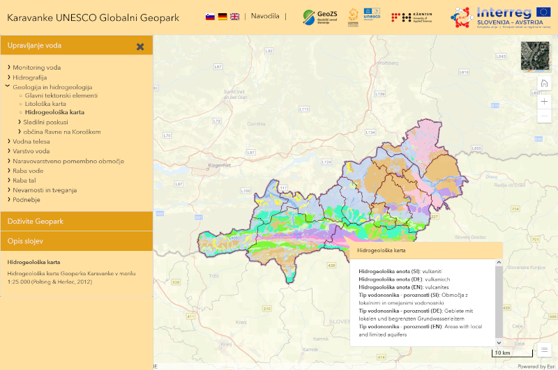
SPLETNI PREGLEDOVALNIK KARAVANKE UNESCO GLOBALNEGA GEOPARKA
Ta trijezični interaktivni spletni pregledovalnik Karavanke UNESCO Globalnega Geoparka je platforma, ki združuje in prikazuje geoprostorske podatke Avstrije in Slovenije v eni aplikaciji.
Ta izjemna priložnosti omogoča 14 partnerskim občinam Karavanke UNESCO Globalnega Geoparka izmenjavo in uskladitev geopodatkov čez državne meje. Zagotavlja enotno vstopno točko za dostop do uradnih prostorskih podatkov, povezuje uporabnike do originalnih podatkov, odgovornih in kontaktnih oseb.
Obiskovalci lahko z izbiro »Doživite Geopark« raziskujete bogato geodiverziteto območja, saj so podane lokacije in opisi geoloških znamenitosti in vodnih fenomenov. Meni »Upravljanje voda« pa je namenjen bolj zahtevnim uporabnikom, ki rabijo poglobljen dostop do podatkov.
Pregledovalnik je dosežek INTERREG V-A SI-AT projekta KaraWAT - Strategija trajnostnega upravljanja vodnih virov v Karavanke UNESCO Globalnem Geoparku. Služi kot orodje, s katerim lahko občine v geoparku čezmejno sodelujejo za zaščito in trajnostno rabo vodnih virov, preprečevanje nesreč in ukrepanje. Platforma podpira tudi trajnostni turizem v geoparku in vabi obiskovalce k raziskovanju naravnih fenomenov in njihovih posebnosti, ogroženosti in načinov za ustrezno zaščito.
Pregledovalnik smo razvili v sodelovanju dveh raziskovalnih organizacij, Geološkega zavoda Slovenije in Univerze uporabnih znanosti Koroške (sedež UNESCO za upravljanje z zaščitenimi območji), in lokalni partner EVTZ Geopark Karawanken m.b.H. Podporo so zagotovili tudi urad Koroške deželne vlade, oddelek št. 8 Okolje, energija in ohranjanje narave in oddelek št. 12 Upravljanje voda, Podzemlje Pece d.o.o., dr. Walter Poltnig, dr. Mihael Brenčič, Direkcija Republike Slovenije za vode, Agencija Republike Slovenije za okolje in programska skupina ARRS P1-0020 Podzemne vode in geokemija.
Ob uporabi portala prosimo navedite naslednji citat:
© Bavdek, J., Kumelj, Š., Bokal, G., Rman, N., Meglič, P., Schmalzl, L., Hartmann, G., Modrej,
D., Lapanje, A., Krivic, M., Šinigoj, M. (2022): Interaktivni spletni pregledovalnik projekta
KaraWAT. Ljubljana, Tihoja, Villach: GeoZS, EVTZ, CUAS. Dostop na https://geopark-karawanken-waters.eu/viewer (navedite datum
dostopa).
KARAWANKEN UNESCO GLOBAL GEOPARK WEB VIEWER
This trilingual interactive web-viewer of the Karawanken UNESCO Global Geopark is a platform to combine and visualize geospatial data from Austria and Slovenia into one single application.
This unique opportunity gives the chance to the 14 partner municipalities of the Karawanken UNESCO Global Geopark to exchange and harmonize their geodata across borders. It provides a single-entry point for accessing official spatial data, linking users to original data displays, responsibilities and contact persons.
Visitors can explore the rich geodiversity of the area using the “Experience Geopark” Menu where locations of geological hotspots and water phenomena are found together with their descriptions. The “Water Management” Menu is aimed at more demanding users who would like to deal with the topic more intensively.
This webviewer is an achievement of the INTERREG V-A SI-AT project KaraWAT - Strategy for the Sustainable Management of Water Resources in the Karawanken-Karavanke UNESCO Global Geopark. It serves as a tool for the Geopark municipalities to work together across-borders for the protection and the sustainable use of water resources, disaster prevention and responses. The platform also supports sustainable tourism within the geopark area as it invites visitors to explore natural features and learn about their peculiarities, threats and possibilities to protect them.
The web viewer was developed in cooperation of two research institutions, the Geological Survey of Slovenia and the University of Applied Sciences Carinthia (UNESCO Chair for the Management of Protected Areas) together with the practical partner EVTZ Geopark Karawanken m.b.H. Support was provided also by the Carinthian Government, Department No. 8 Environment, Energy and Nature Conservation and Department No. 12 Water Management, Podzemlje Pece d.o.o., Dr. Walter Poltnig, Dr. Mihael Brenčič, the Slovenian Water Agency, the Slovenian Environmental Agency and ARRS Program Group P1-0020 Groundwater and Geochemistry.
Please use the following citation to cite the use of the portal:
© Bavdek, J., Kumelj, Š., Bokal, G., Rman, N., Meglič, P., Schmalzl, L., Hartmann, G., Modrej,
D., Lapanje, A., Krivic, M., Šinigoj, M. (2022): Interactive web viewer of the project KaraWAT.
Ljubljana, Tihoja, Villach: GeoZS, EVTZ, CUAS. Accessed at https://geopark-karawanken-waters.eu/viewer (specify date of
accessing data).
KARAWANKEN UNESCO GLOBAL GEOPARK WEBVIEWER
Der dreisprachige interaktive Web-Viewer des UNESCO Global Geopark Karawanken ist eine Plattform, um Geodaten aus Österreich und Slowenien in einer einzigen Anwendung zu kombinieren gemeinsam darzustellen.
Diese einzigartige Möglichkeit gibt den 14 Partnergemeinden des UNESCO Global Geopark Karawanken die Chance, ihre Geodaten grenzüberschreitend auszutauschen und zu harmonisieren. Die Anwendung bietet einen zentralen Zugang zu offiziell verfügbaren Geodaten und verbindet die Nutzer:innen mit den offiziellen Portalen. Sie werden außerdem über Zuständigkeiten und Ansprechpartner:innen informiert.
Besucher:innen des Karawanken UNESCO Global Geoparks können die reiche geologische Vielfalt des Gebiets im Geopark Webviewer über das Menü "Geopark erleben" erkunden, in dem Standorte geologischer Hotspots und Wasserphänomene sowie deren Beschreibungen zu finden sind. Das Menü "Wasserwirtschaft" richtet sich an anspruchsvollere Nutzer:innen, die sich gerne intensiver mit dem Thema beschäftigen möchten.
Dieser Webviewer ist eine Errungenschaft des INTERREG V-A SI-AT Projektes KaraWAT - Strategy for the Sustainable Management of Water Resources in the Karawanken-Karavanke UNESCO Global Geopark. Er dient als Instrument für die Geopark-Gemeinden, um grenzüberschreitend für den Schutz und die nachhaltige Nutzung der Wasserressourcen, sowie im Bereich der Katastrophenprävention und-bekämpfung zusammenzuarbeiten. Die Plattform unterstützt auch den nachhaltigen Tourismus im Geoparkgebiet, da sie Besucher:innen dazu einlädt, die natürlichen Gegebenheiten zu erkunden und etwas über ihre Besonderheiten, Gefährdungen und die Möglichkeiten zu ihrem Schutz zu erfahren.
Der Webviewer wurde in Zusammenarbeit zweier Forschungseinrichtungen, dem Geologischen Dienst Sloweniens, sowie der FH Kärnten (UNESCO Lehrstuhl für das Management von Schutzgebieten) gemeinsam mit dem Praxispartner EVTZ Geopark Karawanken m.b.H. entwickelt. Unterstützung leisteten das Amt der Kärntner Landesregierung, Abteilung Nr. 8 Umwelt, Energie und Naturschutz und Abteilung Nr. 12 Wasserwirtschaft, Podzemlje Pece d.o.o., Dr. Walter Poltnig, Dr. Mihael Brenčič, die Slowenische Wasseragentur, der Slowenischen Umweltagentur und der ARRS-Programmgruppe P1-0020 Grundwasser und Geochemie.
Bitte verwenden Sie die folgende Zitierweise, um die Nutzung des Portals zu belegen:
Bavdek, J., Kumelj, Š., Bokal, G., Rman, N., Meglič, P., Schmalzl, L., Hartmann, G., Modrej, D.,
Lapanje, A., Krivic, M., Šinigoj, M. (2022): Interaktiver Web-Viewer des Projekts KaraWAT.
Ljubljana, Tihoja, Villach: GeoZS, EVTZ, CUAS. Zugänglich unter
https://geopark-karawanken-waters.eu/viewer (Datum des Datenzugriffs angeben).
Poročila / Reports / Berichte
- Vodna strategija Geoparka Karavanke / Wasserstrategie Geopark Karawanken
- Hidrogeološko poročilo o viru mineralne vode Rimski vrelec Kotuljska slatina / Hydrogeologischer Bericht über die Mineralwasserquelle Kärtner Römerquel
- Mineralne vode v Železni kapli / Mineralwasser in Eisenkappel
- Integrirano upravljanje in ekosistemske storitve gozdov / Integrierte Bewirtschaftung und Ökosystemleistungen von Wäldern
- Gradivo delavnice z občinami o vodnih virih in tveganjih, 16. december 2021 / Material des Workshops mit Kommunen zu Wasserressourcen und Risiken, 16. Dezember 2021
- Opozorilna karta nevarnosti za nastanek erozije za občino Ravne na Koroškem / Die Gefahrwarnkarte Vor Erosionsgefahr für die Gemeinde Ravne na Koroškem
- Opozorilna karta nevarnosti za nastanek pobočnih masnih premikov za občino Ravne na Koroškem / Die Gefahrwarnkarte aufgrund der Prozesse der seitlichen Massenbewegung (Erdrutsche, Steinschläge, Trümmerströme)
- Opozorilna karta nevarnosti za nastanek pobočnih masnih premikov in erozije za občino Ravne na Koroškem - Povzetek / Die Gefahrenwarnkarte aufgrund der Prozesse der seitlichen Massenbewegung und Erosions – Zusammenfassung
- Poročilo o konceptualnem modelu pregledovalnika / Bericht über das Konzeptmodell des Online-Viewers
- Poročilo o stanju vodnih virov in tveganjih Avstrija / Bericht Zustand der Wasserressourcen und Risiken Österreich
- Poročilo o stanju vodnih virov in tveganjih Slovenija / Bericht Zustand der Wasserressourcen und Risiken Slowenien
- Poročilo o stanju vodnih virov in tveganjih - skupni dvojezični povzetek / Bericht Zustand der Wasserressourcen und Risiken - gemeinsame zweisprachige Zusammenfassung
- Report on the Status of Water Resources and Risks - joint summary
- Opazovalna postaja za kraške vode Pece / Monitoring Station Karstwasser Petzen
- Hidrogeološka karta s tolmačem občine Ravne na Koroškem / Hydrogeologischen Karte mit Erläuterungen der Gemeinde Ravne na Koroškem
- Povzetek dosežkov projekta Karawat s strategijo 20220825 / Zusammenfassung der Leistungen des Projekts Karawat mit Strategie 20220825